What is PostGIS? GIS extension for PostgreSQL
PostGIS is a powerful open-source software for managing spatial data in a relational database. It enables users to perform advanced spatial analysis and create geospatial applications with ease. This article provides an overview of PostGIS, its key features, and how it can be used to manage and manipulate spatial data within PostgreSQL.
Contents
What is PostGIS? GIS extension for PostgreSQL
This article cartogeek.com defines the advantages it offers PostgreSQL as database open source as well as what is postGIS and what capabilities does it offer to provide space support to PostgreSQL.
The union of PostgreSQL and PostGIS is the most common, widespread and powerful spatial data storage solution in the field GIS open source.
The PostgreSQL database
PostgreSQL is the relational database of type open source most popular and famous on the market. In fact, it is considered the most advanced and complete database of the moment.
It is available for most Operating Systems, from MacOS and Windows to Linux RedHat, Solaris, SuSe or OpenSuSe, Debian and, of course, Ubuntu systems.

The PostgreSQL database It provides great flexibility since it supports multiple languages to program functions such as PLpgSQL, PLPython, PLPHP or PLJava, among others.
Highlight also its security, consistency and integrity, as well as the broad spectrum of supported data types, including:
- Primitive data such as integers, numerics, text strings, booleans.
- Structured Data such as date and time data, arrays or unique identifiers.
- Documents like JSON, XML, Key-value.
- Geometric Data: points, lines, circles and polygons.
- Custom formats
PostGIS: the extension for spatial data
One of the most relevant points is the ability to store and work with geometric data. For this it arises PostGIS: the spatial extension for PostgreSQL, a tool powered by OsGEO.
It is an essential expansion module for PostgreSQL when working on projects GIS.
The extension PostGIS It allows to provide the PostgreSQL relational database with a series of advantages. Among others, the following stand out:
- support for raster and vector GIS files.
- provides spatial analysis, transformation and consultation functions.
- processing speed thanks to spatial indices.
- geocoding tools, 3D, topology, route calculation…
¿What is PostGIS and what is it for?
The extension PostGIS enables support to work with geographic objects located in space.
In other words: converts PostgreSQL into a spatial database, which in practice works ( removing the graphic section ) exactly as a real Geographic Information System desktop.

This is possible because, in addition to allowing the storage of geographic information, the module in question adds a huge package of functions to consult, process, transform and analyze stored spatial information.
Not only that, the execution times GIS analysis based on PostGIS are noticeably shorter and more efficient than any other desktop Geographic Information System.
Therefore, learning to program in SQL to manage and analyze geographic data sets is a key factor.
What allows PostGIS to do?
PostGIS allows you to work with geographic information vector as raster of multiple different formats.
Thus, working with vector formats allows:
- create and edit geometries
- establish spatial relationships between geometric elements
- perform distance analysis and routing with pgRouting
- make topological corrections of elements, etc.
For their part, when working with raster formats, they can be done, among others:
- analysis and band combinations
- edit and reclassify raster layer pixels
- carry out map algebra operations
- generate lift models, etc.
Another relevant point is the ability to link PostGIS easily with Geoserver and Mapserver to be serving spatial geographic information.

In this sense, it is a key piece when integrating pieces of the GIS web architecture for webmapping projects and for share geographic information based on OGC standards.
As we mentioned at the beginning, PostgreSQL supports working with programming languages to include functions. PostGIS allows you to use and schedule triggers ( triggers ) to perform automatic actions that speed work on repetitive tasks.
It may be interesting to know the 25 PostGIS functions for spatial analysis, summarized in an article, explained and with examples.
Also allows to implement spatial indices to considerably speed up the consultation and analysis times of stored and indexed spatial information.
Integration with other GIS software
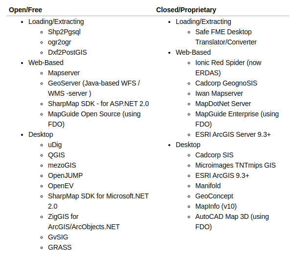
There are a large number of GIS software both Open Source and owner who offer support and make working with PostGIS.
The PostGIS integration with QGIS it is perfect and easy, as we show in another post about the connection of the desktop GIS QGIS with the PostgreSQL spatial database – PostGIS.
The image shows the complete list provided by PostGIS where all the programs that allow PostGIS support are listed.

For all those reasons, the combination of PostgreSQL and PostGIS It has become the cornerstone of many geographic information projects. In a way, its use has become a standard within the GIS sector in the Open Source field.
Read More


